

Nea Irakleitsa
At Nea Irakleitsa, you will find a picturesque harbour framed by one of the most beautiful little villages in the region. Wonderful turquoise seas, with sandy beaches, tavernas, cafes and many beach bars for refreshing breaks, in case you want to spend your whole day there. The beach has some organised facilities and a free car park. You can also get hereby taking the long distance bus for Nea Peramos.
 You are looking for “alana”! There you will find a beach bar to play beach volleyball & beach tennis.
Related Posts
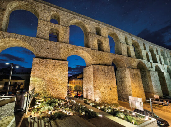
Kamares – Aqueduct
The most characteristic monument of Kavala is the large, arched aqueduct, known by the name “Kamares” (Arches), with a length of 270 m and a maximum height of 25 m. In the early 16th century, the arid peninsula of Panagia found a water supply in the streams that ran from the area of Old Kavala. The source of this water, which is located at an altitude of 400 m, is known as “the mother of the water”, “Soubasi” or the “three Karagatsia”. The Kamares in their present form date to the early 16th century and are attributed to Ibrahim Pasha, the vezir of Sultan Suleiman the Magnificent. They were built in 1520-1530, a period during which many infrastructure works were carried out in Kavala, with the aim of reconstructing the city after the destruction of 1391. The Kamares are a huge structure, out of proportion to the size of the then insignificant settlement. It is believed that there had been a Roman aqueduct on this same spot, over the ruins of which the Kamares were built. This old aqueduct supplied water to the town of Kavala through the region of Suyol (su-yol: “waterway”) until the early decades of the 20th century. The Kamares are no longer of vital importance, but they maintain their beauty and grandeur and are a landmark of the town.
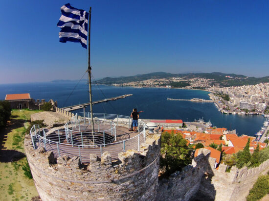
ACROPOLIS – FORTRESS Stronghold of a blue state
The peak of the peninsula of Panagia is dominated by the Acropolis of Kavala, the largest part of which was built in the first quarter of the 15th century AD. It succeeded the Byzantine Acropolis of Christoupolis (an older name for Kavala), which had been destroyed in 1391, the ruins of which were incorporated into its construction. The purpose of the fortress was to control and protect the critical route of the Via Egnatia. The fortress was built on a position with excellent natural defenses and in a period when wars were fought with weapons of “cold steel” and not with missile weapons of mass destruction. The Acropolis was used for the last time during the Second World War by the occupying forces. The successive repairs and intervention to its fortifications, from the Byzantines to the Venetians and the Ottomans, The entire acropolis has been built using unworked local granite blocks, mixed in with pieces of brick and marble. Entering through its central entrance, we can see that it is divided into an inner and an outer precinct by a transverse wall. The inner precinct was the most important part of the acropolis as it contained all the essential areas for its defense. Today, the visitor can see: The central circular tower, which was the last line of defense The gunpowder and food store, which was later converted into a jail The garrison, a space suitable for the quarters of the officers or guards The water cistern Two square and one polygonal tower can be seen in the walls of the outer precinct of the acropolis, while in its inner precinct there is an open-air theater for cultural events and a cafe for visitors.
